Explore the fascinating world of ancient cartography with these 15 intriguing maps. Each map, a piece of history, tells a story of exploration, art, and sometimes misconceptions.
Journey through different cultures and eras, and discover how these maps shaped our understanding of the world.
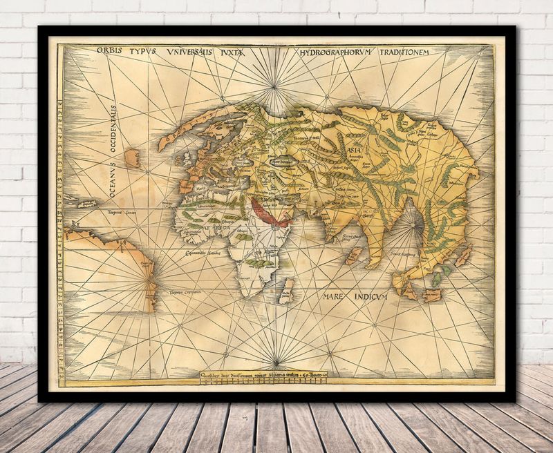
1. Ptolemy’s World Map (Geographia)
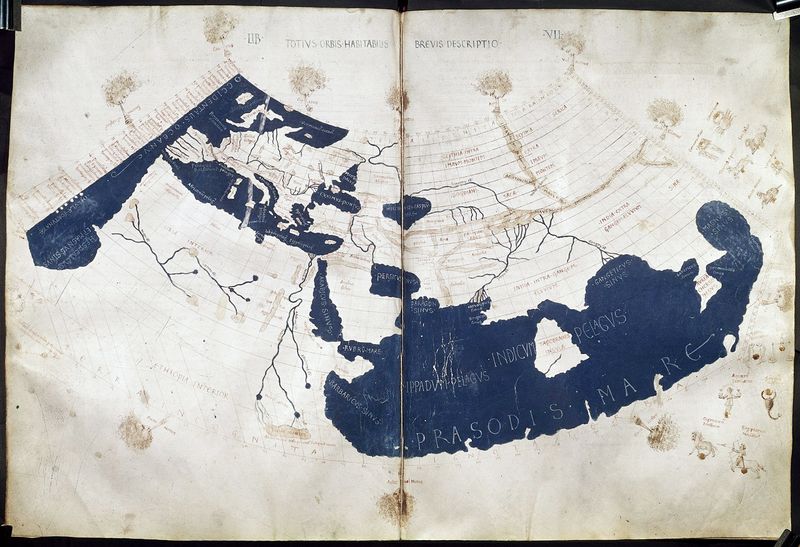
Ptolemy’s World Map from the 2nd century AD is a testament to Greco-Roman knowledge. This map formed the foundation for medieval and Renaissance cartography.
It illustrates the known world through a lens shaped by ancient understanding. Despite its inaccuracies by today’s standards, it was groundbreaking for its time, influencing countless explorers and mapmakers.
The blend of scientific observation and artistic representation made it a revered document in history. Today, it stands as an icon of ancient geography and the thirst for exploration and understanding of the world.
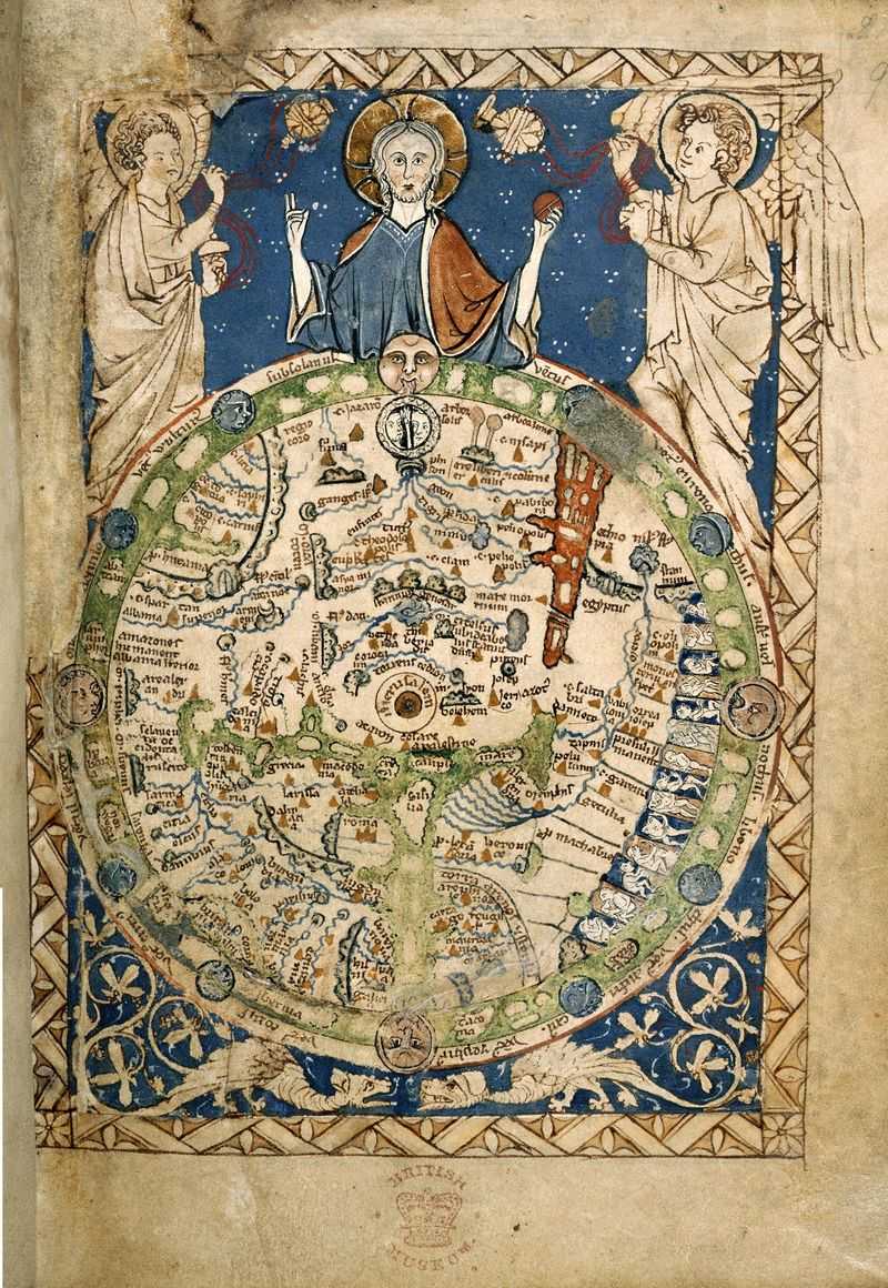
2. Hereford Mappa Mundi
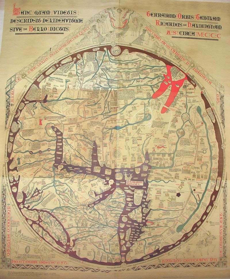
The Hereford Mappa Mundi, crafted around 1300, is a medieval marvel combining biblical history, mythology, and geography. Housed at Hereford Cathedral, this map was once seen as a truthful depiction of the world.
Its circular design reflects medieval Europe’s religious perspectives, placing Jerusalem at the center. While not geographically accurate, it provides insight into medieval belief systems and worldviews.
The map remains a captivating artifact, illustrating how medieval society interpreted the world around them. It’s a blend of art, religion, and geography.
3. Ebstorf Mappa Mundi
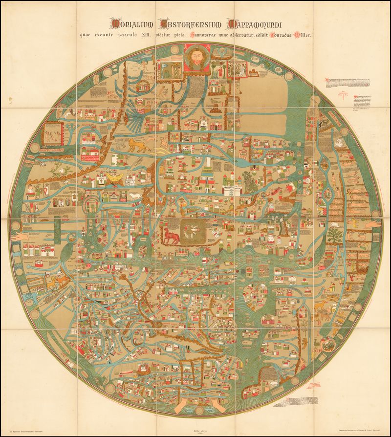
The Ebstorf Mappa Mundi from the 13th century, although lost, was renowned for its detail and blend of historical and mythological elements. It was believed to be a comprehensive vision of the world.
This map exemplified medieval cartography, with its artistic depiction of geography, far from modern accuracy. It’s a window into the medieval mind, merging fact and legend.
Even today, its legacy persists, inspiring scholars and artists alike as a symbol of the era’s creativity and perception of the world.
4. Tabula Rogeriana (Al-Idrisi’s Map)
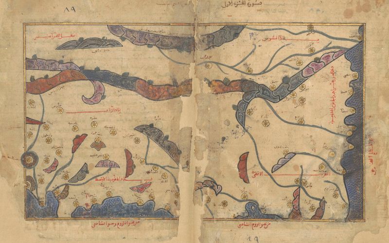
The Tabula Rogeriana, created in 1154 for King Roger II of Sicily, was a blend of Islamic, classical, and local knowledge. Renowned for its relative accuracy, it offered a comprehensive portrayal of the known world.
Al-Idrisi’s work was innovative, illustrating a balance between scientific inquiry and artistic depiction. It showcased the exchange of knowledge between cultures.
This map remained a vital reference for centuries, bridging the East and West. Its legacy continues as a symbol of collaboration and knowledge exchange in cartography.
5. Fra Mauro Map
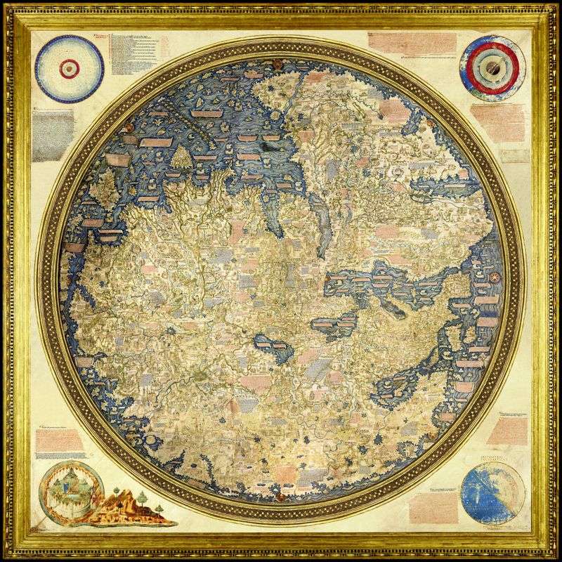
Fra Mauro’s Map, drawn in the mid-15th century, is a masterpiece of detail and accuracy. Created by the Venetian monk Fra Mauro, it offered one of the most precise views of the world available at the time.
This map depicted a world on the verge of the Age of Exploration, capturing both known and speculative geography. It’s celebrated for its artistic beauty and geographical insight.
Fra Mauro’s work remains a testament to the enduring quest for knowledge and understanding of the world, influencing explorers and geographers alike.
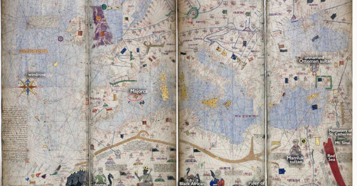
6. Catalan Atlas
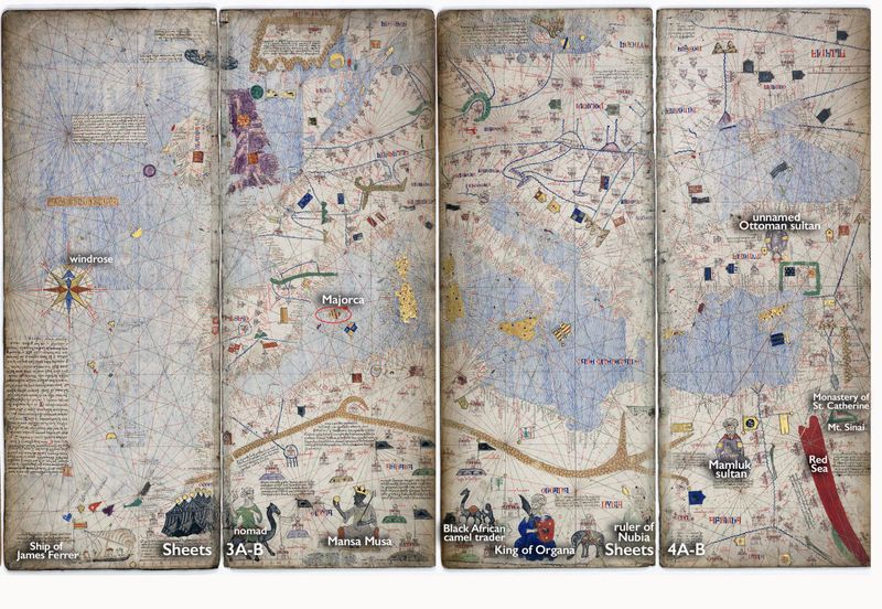
The Catalan Atlas, compiled in 1375 by Abraham Cresques, is esteemed for its rich illustrations and precise depiction of the world. It was influential in medieval Europe, showcasing both the Old World and parts of the New.
This atlas was a blend of art and geography, illustrating trade routes, landmarks, and mythological elements. It inspired future cartographers with its innovative approach.
The Catalan Atlas stands as a symbol of the era’s curiosity and adventure, bridging the gap between medieval and modern cartography.
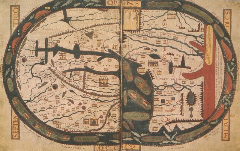
7. Peutinger Table (Tabula Peutingeriana)
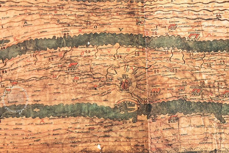
The Peutinger Table, or Tabula Peutingeriana, is a Roman road map presenting the vast network of routes across the Roman Empire. This scroll-like document was accepted as a genuine guide to ancient travel and geography.
It’s unique for its focus on roads rather than geographic accuracy, providing insight into Roman infrastructure. Travelers relied on it for navigating the empire’s expanse.
Though not a conventional map, its impact on understanding Roman connectivity and administration is undeniable, offering a glimpse into ancient logistics and planning.
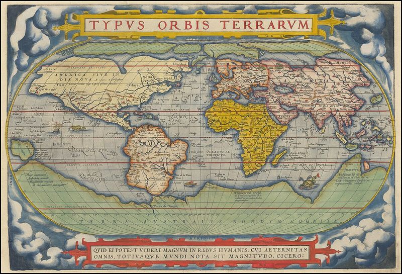
8. Waldseemüller Map
The Waldseemüller Map, published in 1507, is celebrated as the first map to label the New World as “America.” This innovative document was initially regarded as a groundbreaking, accurate global chart.
Its depiction of the Americas was revolutionary, reflecting the era’s exploratory spirit. It synthesized recent discoveries with existing knowledge, reshaping global understanding.
Today, the Waldseemüller Map is a symbol of the transformative age of exploration, highlighting the ever-evolving nature of cartographic science and discovery.
9. Vinland Map

The Vinland Map, allegedly from the 15th century, intrigued scholars with its depiction of Norse exploration in North America. Initially considered genuine, modern studies cast doubt on its authenticity.
Despite controversies, the map’s narrative remains part of cartographic lore, sparking debates and interest. It reflects both the allure and challenge of historical verification.
Whether real or forgery, the Vinland Map continues to capture imaginations, symbolizing the complex relationship between history, myth, and evidence in cartography.
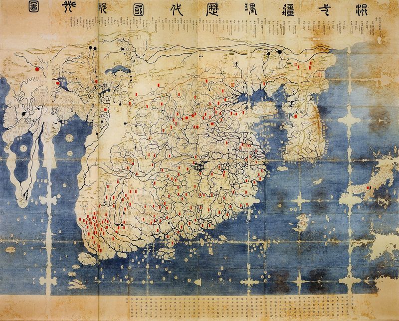
10. Kunyu Wanguo Quantu
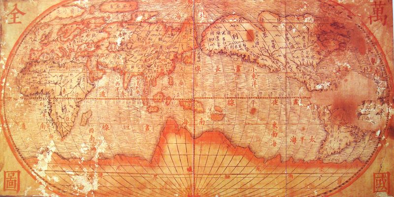
The Kunyu Wanguo Quantu, produced during the early Ming Dynasty, represents a fusion of Chinese and foreign geographical knowledge. It depicts global geography as understood in its era.
This map is notable for integrating Western cartographic techniques with traditional Chinese perspectives. It highlights the cross-cultural exchanges in cartography.
Kunyu Wanguo Quantu remains a fascinating artifact, showing how different cultures approached the science and art of mapping the world, providing a unique view of global understanding.
11. Anaximander’s Map
Anaximander’s Map is one of the earliest known attempts at charting the world, attributed to the pre-Socratic philosopher Anaximander. It laid the groundwork for future Greek cartography.
Though simple and speculative, it was a significant step towards systematic geography. It illustrates the beginnings of scientific inquiry in understanding the Earth’s layout.
This map is a reminder of the ancient curiosity and the origins of cartographic thought, paving the way for more detailed and accurate maps in the centuries that followed.
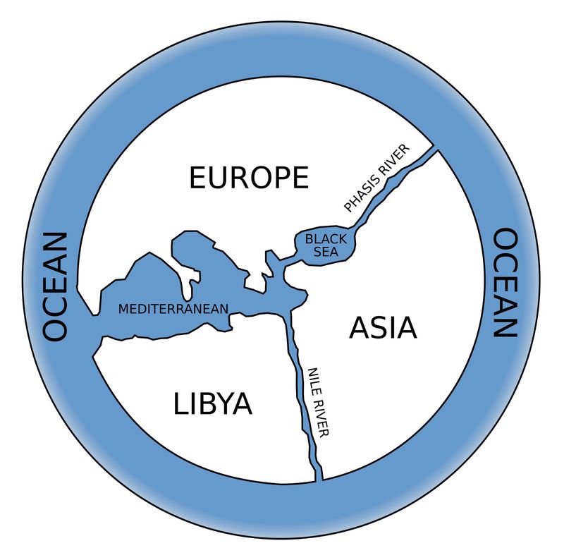
12. T and O Maps (Orbis Terrarum)
T and O Maps, or Orbis Terrarum, are medieval depictions of the world as a circle divided by a ‘T’ into three continents: Asia, Europe, and Africa. They reflect the theological and geographical views of the time.
These maps place Jerusalem at the center, symbolizing religious significance over geographic accuracy. They serve as historical documents of medieval thought.
Though not accurate, T and O Maps offer insight into the medieval worldview, illustrating how religion and geography were intertwined in understanding the Earth.
13. Beatus Maps
Beatus Maps, found in the illuminated manuscripts of Beatus of Liébana’s Apocalypse, combine biblical narratives with geographical imagination. These maps offer a symbolic view of the world.
They blend sacred and earthly elements, illustrating the medieval synthesis of faith and geography. These maps are as much about storytelling as they are about mapping.
Today, Beatus Maps are cherished for their artistry and historical significance, reflecting the medieval quest to comprehend the divine and the worldly in a single image.
14. Psalter World Maps
Psalter World Maps, often included in medieval psalters, merge scriptural history with contemporary geographical knowledge. They served both devotional and educational purposes.
These maps illustrate biblical events alongside known geography, creating a narrative that aligns spiritual and worldly realms. They were tools for meditation and learning.
Psalter World Maps highlight the intersection of faith and learning in medieval times, offering a unique perspective on how people used maps to navigate both the physical and spiritual worlds.
15. Gangnido Map
The Gangnido Map, from the 15th century, is a Korean world map that integrated Chinese and Korean cartographic traditions. It showcases East Asia’s understanding of global geography long before modern maps were developed.
This map is notable for its detail and accuracy within the region, reflecting the sophisticated mapping techniques of the time. It illustrates the exchange of knowledge across cultures.
Gangnido remains a valuable artifact, illustrating the depth of Asian cartographic history and its influence on global mapping practices.